Signal Processing

Six vector maps are selected as experimental data. These maps are referred to as the coastline map, river map, building map, green land map, road map and waterway map, as shown in Fig. 9. The coastline map and river map, both in the China Geodetic Coordinate System 2000 (CGCS2000), can be downloaded from the website of the National Catalogue Service for Geographic Information of China (https://www.webmap.cn).
- Categories:
 6 Views
This dataset contains electromagnetic field (EMF) intensity measurements recorded at half-hour intervals. The dataset spans a continuous timeline, capturing variations in electric field strength in volts per meter (V/m). It serves as a valuable resource for environmental monitoring, predictive modeling, and studying the impacts of EMF exposure. Applications include urban planning, public health assessments, and advanced regression or machine learning modeling.
- Categories:
 14 Views
The data was collected by a tester holding a Xiaomi 13 smartphone while walking and collecting data in an underground parking lot covering a 16x70m area. The data includes 5G radio features and geomagnetic field information.
Collection Time: From 09:58 AM to 10:34 AM on July 13, 2024.
Total Samples: 12,800
Training Set (including validation set): 10,240
Test Set: 2,560
- Categories:
 28 Views
This MATLAB script demonstrates an approach to beamforming and interference suppression in scenarios with multiple users and multiple interferers. It constructs an N-element linear array, computes beamformer weights through a generalized eigen-decomposition of summed desired and interference correlation matrices, and then runs a Monte Carlo simulation to estimate the Signal-to-Interference-plus-Noise Ratio (SINR) for one of the users under random channel conditions.
- Categories:
 116 Views
This paper presents a novel method for non-invasive, cost-effective, and convenient dengue (DNG) detection through smartphone-captured fingertip videos. The proposed method has utilized the ubiquitous technology of smartphones, specifically the camera and built-in light source, to capture photoplethysmog-raphy (PPG) signals for identifying DNG. This contrasts sharply with traditional needle-based methods.
- Categories:
 39 Views
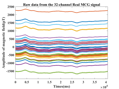
Cardiac functional imaging plays a crucial role in the detection, diagnosis, and prognosis of major cardiac diseases. Magnetocardiography (MCG) provides the benefits of non-invasive measurement and precise reflection of signals generated by the heart’s contraction and relaxation, and is gaining prominence in medical technology. However, due to various reasons, the reviewed dataset was not available and no standard dataset has been published on this topic.
- Categories:
 110 Views
A high-quality dataset is essential for validating the effectiveness and accuracy of the proposed compression method. To assess the feasibility of the research methodology, we collected neural signals from 96 channels recorded from two non-human primates using the Blackrock Microsystems system and the Blackrock Cerebus, with a sampling rate of 30 kHz.
- Categories:
 31 Views
Walking-friendly cities not only promote health and environmental benefits but also play crucial roles in urban development and local economic revitalization. Generally, pedestrian interviews and surveys used to evaluate walkability, but this is expensive and lack professional insight. To address limitations in current methods for evaluating pedestrian pathways, we propose a novel approach utilizing wearable sensors and deep learning.
- Categories:
 91 Views
A multimodal dataset is presented for the cognitive fatigue assessment of physiological minimally invasive sensory data of Electrocardiography (ECG) and Electrodermal Activity (EDA) and self-reporting scores of cognitive fatigue during HRI. Data were collected from 16 non-STEM participants, up to three visits each, during which the subjects interacted with a robot to prepare a meal and get ready for work. For some of the visits, a well-established cognitive test was used to induce cognitive fatigue.
- Categories:
 39 Views
In this article, a novel method for interferometric target detection that employs coherent echoes and spatial frequency sampling is proposed. Originating from radio astronomy, interferometric passive microwave imaging has become widely applied for the passive microwave remote sensing of Earth. The proposed technique, termed Interferometric Coherent Echo Detection, is a novel active imaging method that capitalizes on coherent echoes to sample the spatial frequency domain.
- Categories:
 7 Views
